Underwater, my friends.
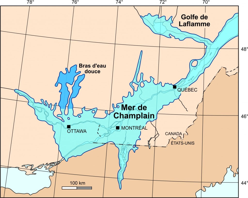
The de-glaciation process had recently begun and given birth to the Sea of Champlain which was a temporary inlet of the Atlantic Ocean, created by the retreating glaciers during the close of the last ice age. This sea of saltwater was born about 13 000 years ago when the glacier began melting. It slowly shrank allowing the rebounding continent to slowly rise above sea level. The sea was home to crustaceans, seals, walrus and belugas whose fossils were found in the Lower Laurentians.
In 2001, the skeleton of of a 10 700 year old beluga was found in Saint-Félix-de-Valois, 118 kilometers east of Dunany. It was the best preserved of the 21 specimens found to date. Interestingly, it proved to be morphologically identical to the belugas found today in the St-Lawrence River. The vegetation found around the shores of this salted inland sea was pretty similar to the tundra now found in Northern Quebec.
Lake Lampsilis (known today as Lac St-Pierre, east of Montreal) is the name given to the body of fresh water that was left after the sea of Champlain had retreated. The sea lasted from about 13 000 years ago to about 10 000 years ago and shrank continuously during that period. The actual shoreline of the St-Lawrence took today’s shape about 8 000 years ago.
The melting of all this ice – about two kilometers thick – removed a lot of weight permitting the earth’s crust to slowly lift. That is how the Laurentians and their thousands of lakes were created. If you wish to see how this evolved over time, have a look at this simulation.
As you can see, our geological history is pretty recent considering that humans were living in Europe more than half a million years ago!
Sources: Biodôme de Montréal, Wikipedia


Outstanding post, learned a thing or two for sure. Great job Jacques, keep up the hard work!
Enfin, j’ai pris le temps de visionner ton exposé!!!! Fantastique Jacques! Très intéressant! Beau travail!
this is super cool, thanks Jacques
What wonderful information, thank you so much for making us aware of it and the link.
Great information Jacques , thank you for sharing that with us. Most interesting!
Anyone who wishes to view The Rise and Fall of the Great Lakes can do so by clinking on this link: https://youtu.be/afs_A_Lz2w4
And thanks for the nice complement to my Post, Tony.
Being dyslectic, it should read, turning right on Laurin and the rock face is on the left.
Thank you Jacques for the introduction to our historical geography. To those who want a great lesson in geography – then The National Film Board has a fantastic film that amused and taught my students “The Rise and Fall of the Great Lakes” directed and written by Bill Mason. Now for some local geography – The “Grenville Fault Line” is the dividing line between the Canadian Shield (Seen easily by the rock face on your right along Laurin road) and the St. Lawrence Lowlands. The North River from St. Jerome follows the Line. Coming down the hill from the Brownsburg curling club, you will see wave cut terraces to the flats going towards St.Phillipe. The deep ditches were created by the outwash of the sea. For the City of Montreal, as you come down from the top of the mountain, the parallel streets are all on the flats of the wave-cut terraces (Pine Ave). Drilling for water near St. Benoit, farmers have struck salt water. When you cross the bridge back to “Canada” (Quebec) the Canadian Shield stands out beautifully. Good golf and skiing!
Fascinating Jacques. Thanks for posting this.